How to Find Ley Lines Near You: Maps, Methods and Fieldwork
A practical guide to finding and investigating possible ley lines using maps, archaeology and fieldwork, while separating landscape evidence from spiritual interpretation.

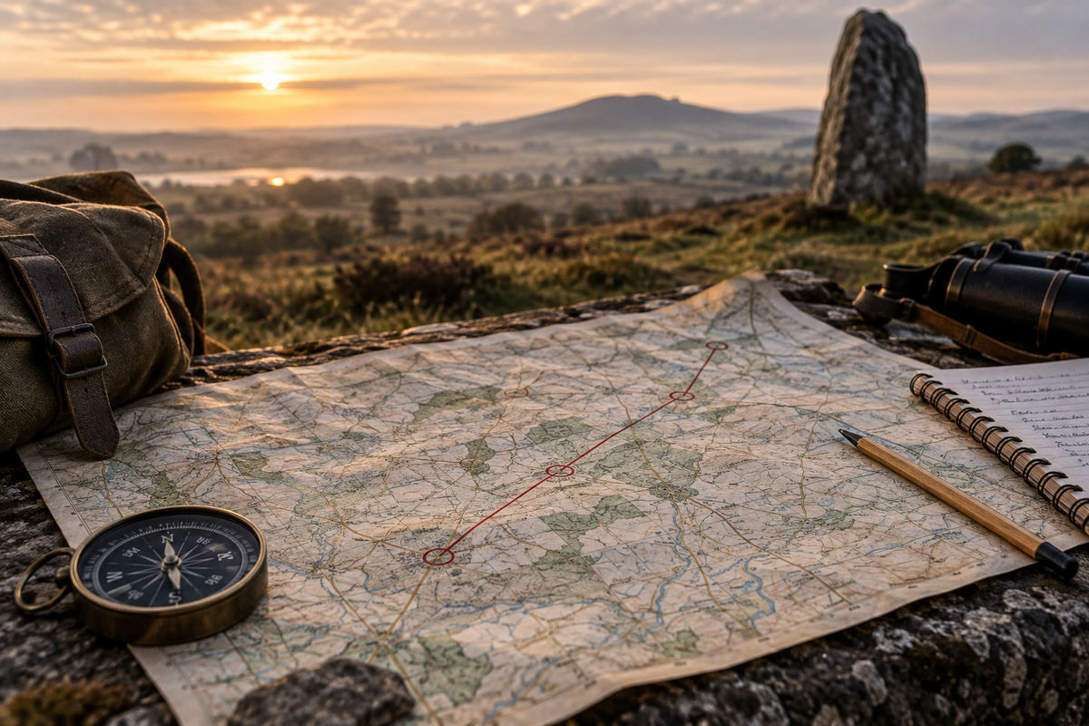
Ley lines begin with a surprisingly simple act: looking at a map and noticing that old places line up.
If you want to search for possible ley lines near you, start by plotting ancient monuments, old churches, holy wells, prehistoric mounds, hilltops and historic tracks. Look for three or more independently chosen places that form a narrow straight alignment. Then investigate the dates, geography and history of those places before going out to walk the landscape yourself.
Some ley hunters go further. They use dowsing rods, pendulums, compass readings or bodily sensations to explore a possible line.
Those practices can form part of a personal investigation. They do not, however, establish scientifically that an invisible energy line exists.
That distinction is central to the Sacred Illusion approach.
How to find a possible ley line in five steps
- Choose a manageable area. Start with a few square miles somewhere you know or can visit easily.
- Mark possible ley points. Plot ancient monuments, churches, wells, hilltops, crossroads and historic tracks.
- Look for alignments. Find groups of at least three independently selected points that fall on, or very close to, a straight line.
- Test the evidence. Check the age of each site, the terrain and the historical relationship between the places. Look deliberately for ordinary explanations.
- Walk the line. Visit accessible points, record what you observe and, where possible, return under different conditions.
That is the basic practice of ley hunting.
The interesting part begins when the straight marks on the map meet the complicated physical landscape.
First: what exactly is a ley line?
A ley line is a proposed straight alignment connecting significant features in the landscape.
Depending on who is drawing the line, those features might include standing stones, burial mounds, hill forts, ancient churches, holy wells, crossroads, prominent hills or other landmarks.
The modern story of ley lines begins with Alfred Watkins, a Herefordshire businessman, photographer and antiquarian.
In 1921, Watkins became convinced that many old sites in the British landscape formed long straight alignments. He proposed that these were remnants of ancient routes, with travellers moving between visible landmarks long before modern roads and signposts.
He developed the idea in Early British Trackways and, later, The Old Straight Track.
There is an important detail here that often disappears from modern accounts of ley lines:
Watkins was not originally describing a global network of mystical energy currents.
He was looking for ancient landscape alignments and possible trackways.
The idea of ley lines as channels of earth energy developed later through dowsers, esoteric writers and the Earth Mysteries movement.
Today, the phrase therefore tends to describe two related but different ideas:
- Landscape alignments: straight lines linking old or significant sites, which might represent routes, sightlines, boundaries, ceremonial axes or other deliberate relationships.
- Earth-energy lines: invisible currents that some practitioners believe can be sensed, dowsed or experienced at particular places.
It is possible to investigate either idea without assuming in advance that the other is true.
A straight line on a map is an observation.
Why that line exists, and whether it means anything, is a separate question.
Step 1: choose the right map
Start locally. A small area is much more useful than trying to draw enormous lines across an entire country. You can examine the sites properly, understand the terrain and actually visit the places involved.
Ordnance Survey maps
For British fieldwork, an Ordnance Survey Explorer map is one of the most useful tools you can have.
At 1:25,000 scale it shows much more landscape detail than an ordinary road map, including rights of way, contours and many historic features.
Look for features such as:
- standing stones and stone circles
- tumuli, barrows, cairns and mounds
- earthworks and ancient enclosures
- forts and camps
- wells and springs
- churches, chapels and ruins
- crosses, beacons and towers
- Roman roads and old tracks
- prominent hills and distinctive changes in the skyline
A paper map has another advantage. It lets you see the whole landscape at once. On a screen, the software constantly changes what is visible as you zoom. A large physical map can make relationships between places easier to notice.
Google Earth
Google Earth is excellent for the next stage. Plot candidate sites as placemarks and draw lines between them. Then change the viewing angle.
An alignment that looks persuasive on a flat map may suddenly seem less convincing when you discover that it crosses a steep escarpment, deep valley, river or other major obstacle.
Satellite imagery can also reveal tracks, field boundaries and relationships between landscape features that are difficult to see on a conventional map.
If you import somebody else's ley-line or earth-grid overlay, remember what you are looking at: it is a map of someone's theory, not an official map of a proven physical network.
Archaeological records
This is where ley hunting becomes much more interesting. Before assuming that several places belong together, find out what those places actually are and when they were created.
In England, Historic Environment Records and the Heritage Gateway can provide details about archaeological sites and historic buildings. Wales and Scotland have their own national and local historic-environment resources.
These records can tell you that a mound thought to be prehistoric is much later, or that sites which appear to form one ancient alignment were actually created thousands of years apart.
That does not make the geometry disappear. It changes what the geometry can reasonably be said to mean.
Step 2: choose your possible ley points
Watkins used the term mark points for features that appeared to sit upon his proposed alignments.
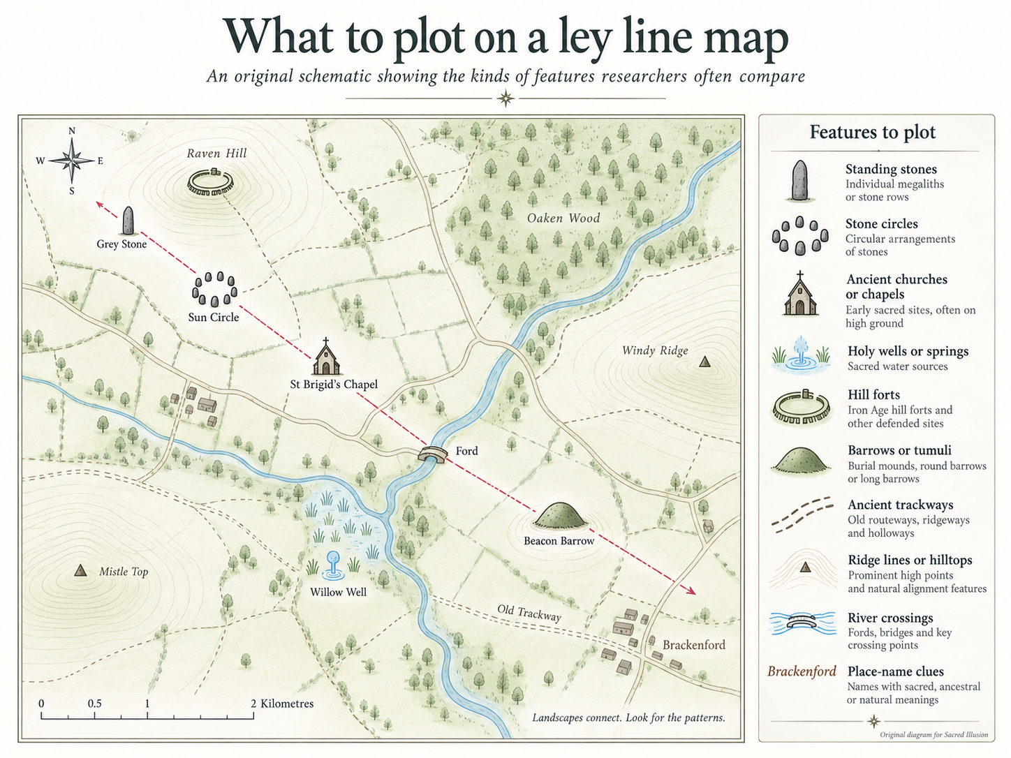
For a modern investigation, useful candidates might include:
- standing stones and stone circles
- long barrows, round barrows and cairns
- prehistoric enclosures and hill forts
- ancient wells and springs
- beacon hills and prominent summits
- old crossroads and fords
- ruined chapels
- early churches
- church towers on prominent ground
- ancient yews
- old tracks
- distinctive gaps or notches in a skyline
Be especially careful with churches
Churches appear frequently on ley-line maps. There are good reasons for this. Churches are visually prominent, have often occupied the same location for centuries and sometimes stand at places with evidence of earlier activity.
But Britain also contains thousands of churches.
With enough points on a map, chance alignments become increasingly easy to find.
Do not assume that an old church automatically replaced a pagan temple or prehistoric sanctuary. Sometimes there is archaeological or documentary evidence for earlier use. Sometimes there is not.
Be careful with place names too
Place names can be fascinating clues to landscape history, but they are easy to overinterpret.
The fact that a modern place contains a particular syllable does not establish that it belonged to an ancient ley system. Use names as questions to investigate, not answers.
Record the points before drawing the line
This is a small but powerful discipline.
Choose and record your candidate sites before you begin looking for alignments.
Otherwise it is very easy to keep adding places that happen to support the pattern while unconsciously ignoring those that do not.
Step 3: draw the line
Two points will always produce a straight line.
A third independently selected point makes the pattern more interesting.
Four or five compatible sites lying close to the same narrow alignment deserve closer investigation.
But decide something before you start:
How wide is your ley line allowed to be?
A thick pencil stroke on a small map can represent hundreds of metres on the ground.
The wider the corridor becomes, the easier it is to catch additional landmarks.
For every proposed line, record:
- the places it includes
- exact coordinates where possible
- the approximate age of each site
- the type of site
- the length of the proposed alignment
- how far each point sits from its centre
- its bearing
- similar nearby sites that do not fit the alignment
- known historical or geographical connections between the places
Then examine the landscape.
Does the line follow a ridge?
Does it connect visible hilltops?
Could someone realistically have travelled along it?
Do the sites have intervisibility?
Does the line correspond with an old route, boundary or astronomical orientation?
Does it cross terrain that would have made travel implausible?
A meaningful alignment need not have been a road. It could conceivably relate to a sightline, boundary, ceremonial axis or astronomical relationship.
But the physical landscape should help determine which explanations remain plausible.
Step 4: try to disprove your ley line
This may sound like an odd instruction on a site about ley lines. It is probably the most useful one.
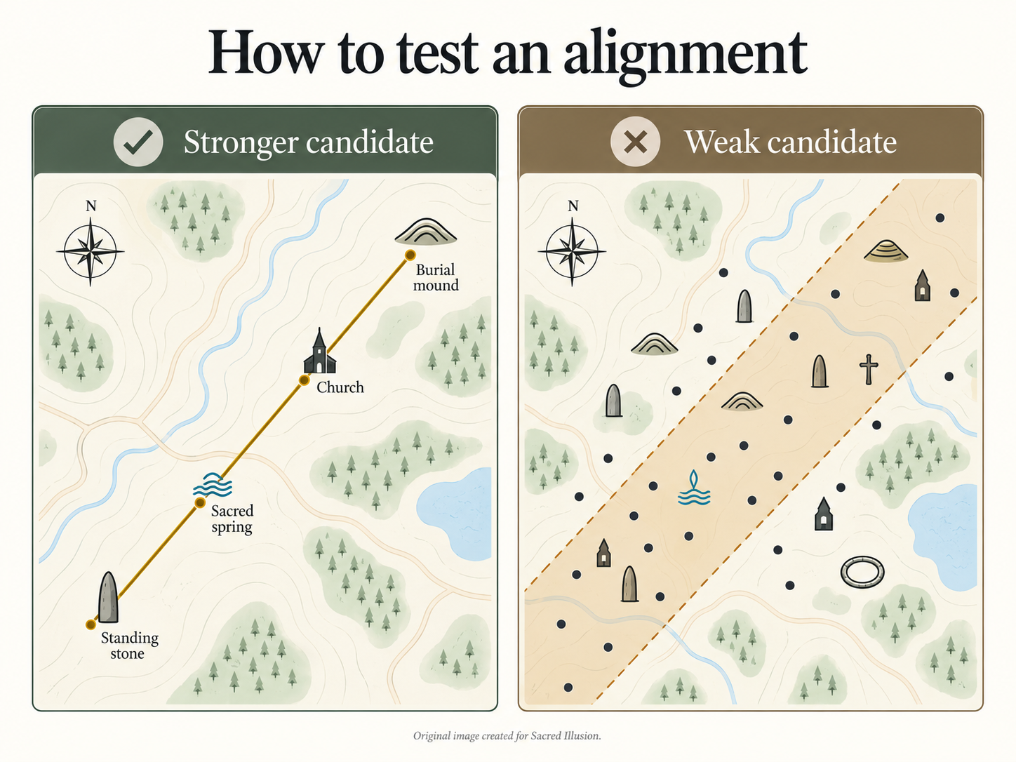
Britain contains an enormous number of old churches, monuments, mounds, wells, roads and named hills.
If you draw enough lines across enough points, striking alignments will appear.
Mathematician Matt Parker famously demonstrated the problem by finding apparently impressive alignments using former Woolworths stores.
That does not prove that every landscape alignment is meaningless.
It demonstrates why an alignment needs more evidence than the simple fact that points can be connected.
Before becoming attached to your line, ask:
- Did I choose the sites before drawing it?
- Were the sites created in compatible periods?
- Have I mixed prehistoric monuments, medieval buildings and modern structures simply because they fit?
- How far from the centre line am I allowing a point to fall?
- How many similar places nearby do not fit?
- Could a slightly different line produce an equally impressive pattern?
- Does this line make sense when I look at the terrain?
- Is there historical evidence connecting any of the locations?
This does not remove the mystery.
It makes the mystery harder-earned.
A famous example: the St Michael Line
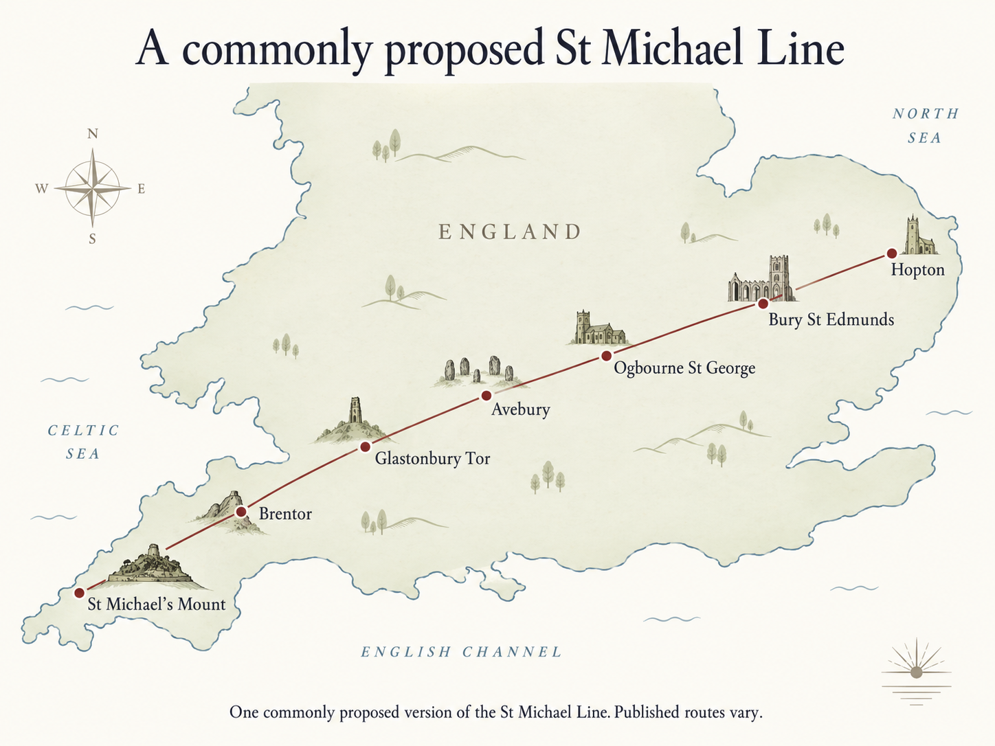
One of Britain's best-known claimed ley lines is the St Michael Line, drawn across southern England from Cornwall towards East Anglia.
Locations associated with different versions of the alignment include St Michael's Mount, Glastonbury and Avebury, alongside a number of churches dedicated to St Michael.
The line has acquired several layers of interpretation.
Some writers have associated its direction with sunrise around the beginning of May and the traditional festival season of Beltane. Later earth-mystery traditions also connect St Michael, the dragon-slayer, with ideas about dragon currents or energies in the landscape.
But there is no single universally agreed St Michael Line.
Different maps include different sites and allow different widths. Some accounts also distinguish the straight mapped alignment from the Michael and Mary currents described by dowsers.
That makes it an excellent case study.
Rather than asking simply, “Is the St Michael Line real?”, try asking:
- Which version of the line am I testing?
- What sites does that version include?
- How precisely do they align?
- When were those places established?
- Are there known historical links between them?
- Does the alignment correspond with landscape or astronomical features?
- Which claims are geographical, which are historical and which come from later spiritual traditions?
Those questions produce a much more interesting investigation than beginning with a predetermined answer.
Step 5: walk the line
Maps flatten the world.
Fieldwork puts back the hills, mud, weather, trees, roads, sounds, sightlines and distances.
Choose publicly accessible sites or rights of way and start with a manageable part of your proposed alignment.
Take:
- your map or an offline digital map
- a compass
- a notebook and pencil
- a phone or GPS device
- a camera
- suitable outdoor clothing
- dowsing rods or a pendulum, if those form part of your practice
Observe before you interpret
At each site, first record what is physically present.
Note:
- date and time
- weather
- exact location
- visibility
- nearby roads
- buildings
- pylons or electrical infrastructure
- water
- obvious geological features
- other people
- sounds
- anything unusual you notice
Photograph the view in several directions.
Then record your subjective experience separately.
Did the place feel calm, uncomfortable, powerful, familiar or entirely ordinary?
Keeping observation and interpretation separate produces much more useful field notes.
The Sacred Illusion Node Quest method
This is the approach I use, and will develop further through Sacred Illusion's Node Quests.
For any unusual place or proposed energy point, record four layers:
1. Place
What is physically here?
2. History
What do reliable sources tell us happened here?
3. Tradition
What stories, spiritual interpretations or esoteric claims have become associated with it?
4. Experience
What, if anything, do I actually notice when I am there?
Do not force those layers to agree.
Sometimes the most interesting investigation begins when they do not.
How to use dowsing rods for ley lines
Dowsing has long been used by practitioners searching for underground water, buried objects and supposed earth energies.
Ley hunters commonly use two L-shaped rods held loosely in front of the body.
If you want to experiment:
- Settle your stance and breathing.
- Hold the rods loosely enough that they can move.
- Decide beforehand what response you will regard as significant.
- Walk slowly across the suspected line.
- Mark any point where the rods consistently respond.
- Repeat the walk from the opposite direction.
- Repeat the experiment.
- If possible, ask another person to test the area without telling them where your mark is.
There are several possible explanations for rod movement.
Small unconscious muscular movements can affect them. Wind, uneven ground and expectations may influence what happens. Pipes, water, fences and other infrastructure may complicate the environment.
Some practitioners interpret the rods as amplifying subtle bodily responses. Others believe they detect an external field.
Controlled scientific research has not established dowsing as a reliable method for detecting ley lines.
That does not prevent you from experimenting with it.
It means your notes should distinguish:
Observation: “The rods crossed repeatedly at this location.”
from:
Interpretation: “An earth-energy line passes through this location.”
Those are not the same statement.
Can a compass detect a ley line?
A normal magnetic compass cannot identify a ley line.
It responds primarily to the Earth's magnetic field.
Local disturbance may be caused by iron-rich rocks, vehicles, fences, electrical equipment, buildings or buried metal.
If you notice an unusual compass reading:
- move away from obvious sources of interference
- repeat the measurement
- use a second compass if possible
- record the precise location
- compare it with nearby control locations
An anomaly is worth recording.
It is not, by itself, proof of a ley line.
Can you sense a ley line without tools?
People who visit places they consider energetically significant report many different sensations, including:
- tingling
- temperature changes
- pressure around the head or chest
- sudden calm
- heightened alertness
- changes in breathing
- unexpected emotion
- a sense of presence or connection
Those experiences can be powerful.
They can also be influenced by expectation, exertion, landscape, acoustics, weather, story and the knowledge that generations of people have treated a particular place as sacred.
You do not need to choose immediately between “it was energy” and “it was nothing”.
Record what happened.
Return under different conditions if you can.
Compare the supposed line with somewhere nearby.
Ask another person what they notice before telling them what you expect.
Experience deserves attention. It does not automatically become evidence of its proposed explanation.
Common ley-hunting mistakes
Starting with the answer
If you decide where the line ought to run before choosing the sites, it is remarkably easy to find supporting points.
Choose your candidate sites first.
Making the line too wide
A broad corridor catches more landmarks and makes weak alignments appear stronger.
Record your scale and tolerance.
Mixing unrelated periods
A Bronze Age barrow, medieval church and Victorian tower can fall on a perfect straight line.
The geometry alone does not demonstrate that anybody deliberately connected them.
Assuming every anomaly is energy
Power lines, pipes, phones, geology and metal affect instruments.
Cold, fatigue, expectation and emotion affect people.
Record the anomaly first. Explain it later.
Trusting somebody else's map
Online ley-line maps are fascinating starting points, but they frequently reproduce earlier maps without explaining how the lines were constructed.
Ask who created the map, which points were selected and what margin of error was allowed.
Forgetting that sacred places are real places
Some proposed ley points are active churches, burial places, protected monuments or private land.
Do not climb fragile structures, move stones, dig, light fires or leave objects behind.
A spiritual investigation does not confer special access to someone else's land or a protected archaeological site.
Ley lines and other cultural traditions
It is tempting to describe every tradition involving sacred routes or landscape relationships as another form of ley line.
That can distort very different systems of meaning.
Chinese ideas about dragon veins, European fairy paths and Aboriginal Australian Songlines emerge from distinct cultures, histories and cosmologies.
Songlines in particular are not simply an Australian version of a British ley-line theory. They are connected to living Indigenous knowledge, Country, law, ancestry and navigation.
Comparison can be illuminating.
Equivalence should not be assumed.
So, are ley lines real?
Straight alignments between significant places certainly exist on maps.
Some correspond with known roads, boundaries, astronomical orientations, landscape features or deliberate architectural axes.
Others can arise through chance, particularly when large numbers of possible points are available.
What has not been scientifically established is the existence of a global invisible network of energy lines running through the Earth.
That still leaves fascinating questions.
- Why were particular sites chosen?
- Which routes connected ancient communities?
- How did people navigate through landscape before maps?
- Why are hills, springs, crossroads and particular orientations repeatedly associated with sacred places?
- Why do certain locations continue to exert such a strong psychological or spiritual pull?
- And what happens when historical research, landscape observation and personal experience all meet in the same place?
Ley hunting is most interesting when those questions remain genuinely open.
Draw the line. Check the records. Walk the ground. Notice what happens. Then decide how much the pattern can honestly carry.
Frequently asked questions
How can I find ley lines near my house?
Start with an Ordnance Survey map or Google Earth and identify ancient monuments, old churches, wells, mounds, hilltops and historic tracks within a manageable distance. Select the sites before drawing lines between them. Look for narrow alignments involving at least three points, then investigate the date and history of each location before visiting accessible sites.
Is there an official UK ley-line map?
No. There is no official or scientifically recognised map of UK ley lines. Published ley-line maps use different theories, landmark selections and line widths. Treat them as proposals to investigate rather than authoritative maps of a known physical network.
Can I find ley lines using Google Earth?
Yes, Google Earth is useful for testing proposed landscape alignments. Plot candidate sites, draw lines between them, measure distances and tilt the landscape to see how the proposed route relates to the actual terrain.
Do ley lines run through churches?
Many claimed ley lines include churches. That does not automatically establish a historic or energetic connection. Britain has thousands of churches, so chance alignments are inevitable. Investigate the history of the individual site and the dates of the other places on the proposed line.
What happens if you live on a ley line?
There is no verified physical effect associated with living on a claimed ley line. Some people report unusual dreams, sensations, creativity or disturbances, while others notice nothing. Ordinary environmental explanations should be considered before attributing an experience to a ley line.
Can dowsing prove a ley line exists?
No accepted scientific test has established dowsing as proof of ley lines. It can still be used as a personal exploratory practice, especially if observations are repeated and compared with control locations.
What is Britain's most famous ley line?
The St Michael Line is probably the best-known claimed British ley line. Different versions are drawn across southern England through or near locations including St Michael's Mount, Glastonbury and Avebury, but its precise route differs between maps.
Continue exploring
New to the subject? Read What Are Ley Lines? next for the history of Alfred Watkins, the development of earth-energy theories and the arguments for and against ley lines.
For the bigger picture, explore The Earth's Energy Grid: Ley Lines, Nodes and the Networked Planet.
And if you want to investigate these ideas outside the screen, look out for Sacred Illusion Node Quests, field notes and the forthcoming ley-line fieldwork resources.