Ley Lines in London: Sacred Geometry or Spiritual Infrastructure?
Do ley lines run through London? Explore historic routes, sacred landmarks, claimed alignments and the evidence behind London's hidden geometry.

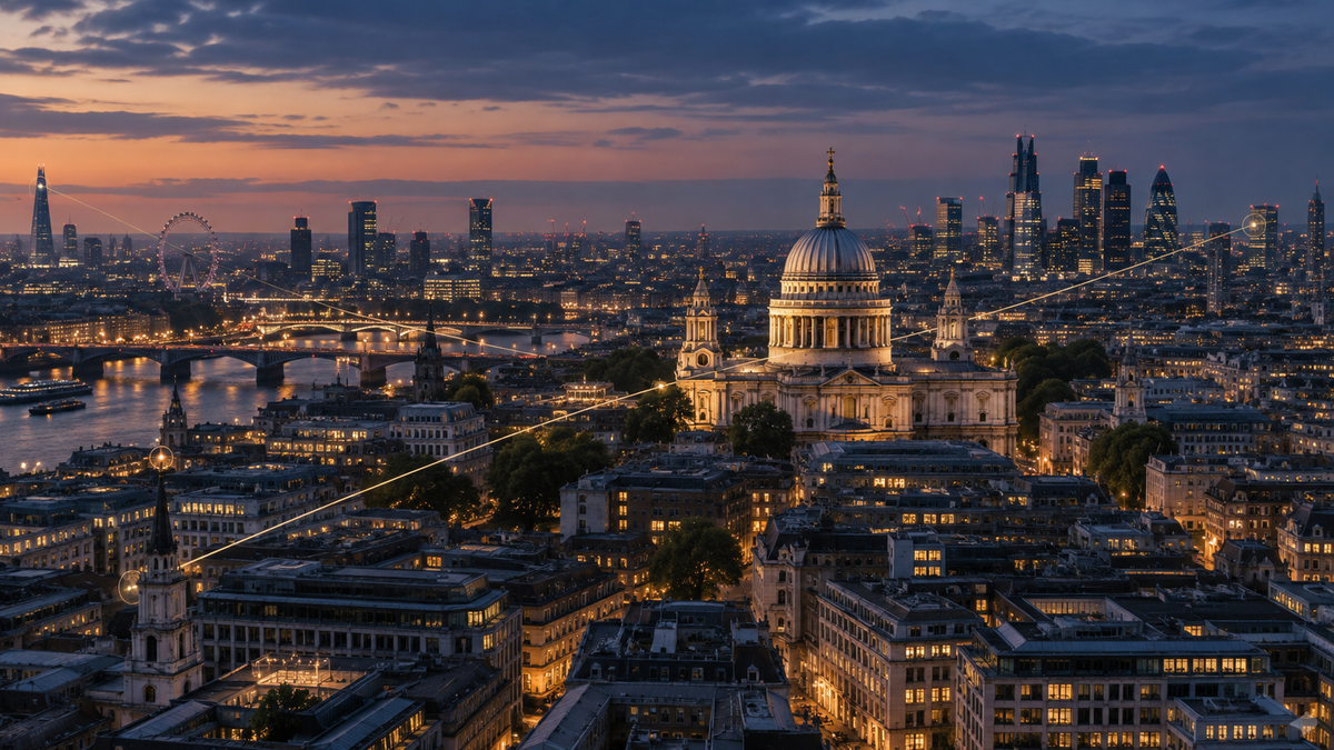
London is one of the easiest places in Britain to draw a convincing ley line.
That is partly because the city contains an extraordinary concentration of old churches, monuments, wells, ancient roads, hills, ceremonial routes, buried rivers and historic centres of power. Draw enough lines across that landscape and some of them are bound to look significant.
But London creates a more interesting problem than simple coincidence.
This is also a city that really has been shaped by axes, sightlines, processional routes, symbolic architecture and carefully protected relationships between landmarks. St Paul's Cathedral, Westminster Abbey and the Tower of London are not randomly scattered buildings. They sit within a city whose geography has accumulated meaning for nearly two thousand years.
So when people talk about London's ley lines, what exactly are they seeing?
A hidden energetic network? Deliberate sacred geometry? Historic routes and sightlines that later acquired mystical interpretations? Or simply the human ability to find patterns in an exceptionally dense city?
The answer may depend upon which London line you are looking at.
What do people mean by London's ley lines?
There is no single official map of London ley lines.
Different writers have proposed different systems, sometimes connecting churches, ancient mounds, wells and monuments, and sometimes projecting much larger geometric patterns across the capital.
Some claims descend from the broader ley-line tradition associated with Alfred Watkins. Others grew through twentieth-century Earth Mysteries, psychogeography and modern sacred-geography writing.
The theories frequently focus on recurring London landmarks such as St Paul's Cathedral, Westminster Abbey, the Tower of London, London Stone, Greenwich, ancient wells and the many churches that sit along older streets.
What makes London especially interesting is that some of these relationships are unquestionably deliberate.
The question is whether deliberate urban geometry is the same thing as a ley line.
It isn't necessarily.
London really is organised by lines
Before considering invisible lines, it is worth noticing the visible ones.
Cities depend upon routes, boundaries and sightlines. London has Roman roads, medieval processional routes, bridges, parish boundaries, royal routes and avenues deliberately designed around monuments.
Even today, London's planning system actively protects certain visual relationships.
The London View Management Framework protects strategic views across the capital, including vistas towards St Paul's Cathedral, the Palace of Westminster and the Tower of London. New development can be restricted precisely because London considers some long-distance relationships between place and landmark important.
That is not evidence of Earth energy.
It is, however, proof that a city can be deliberately shaped around lines that carry cultural and symbolic importance.
That distinction becomes useful when looking at older London.
The City and Westminster: two centres of power
For centuries, London has contained two particularly important centres.
The City of London developed around commerce, government and the old Roman settlement. Several miles west, Westminster became the centre of royal, religious and later parliamentary power.
Westminster itself grew around Thorney Island, a marshy area surrounded by channels of the River Tyburn. Edward the Confessor established his palace there and enlarged the Benedictine monastery that eventually became Westminster Abbey.
Between Westminster and the City ran important ceremonial and commercial routes.
This already creates an intriguing sacred geography without requiring an invisible grid.
Two centres of authority, connected through a landscape of churches, gates, monuments, markets and processional space.
The London Sovereign Line
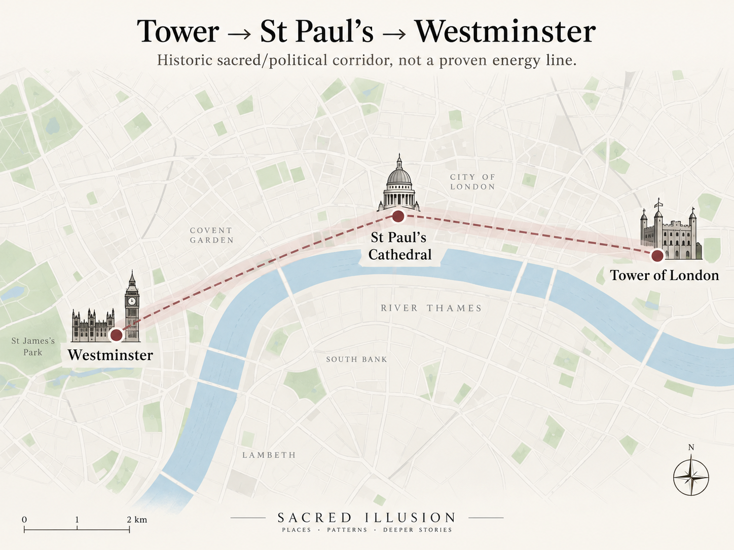
One of the most interesting ways to experience this geography today is the route sometimes called the London Sovereign Line or Coronation Route.
The British Pilgrimage Trust maps a roughly five-mile route from the Tower of London through the City, past St Paul's and onwards towards Westminster Abbey. It follows London's historic relationship between the commercial City and the royal and religious centre at Westminster.
The route encounters an extraordinary density of meaningful places: old churches, London Stone, former city boundaries, the Strand, ceremonial spaces and the Abbey itself.
Calling this a ley line would go beyond the historical evidence.
Calling it a sacred route through London's historic power centres is much easier to defend.
And that creates an interesting possibility.
Some things later described as ley lines may preserve relationships that were culturally important even if they were never understood as currents of invisible energy.
London Stone: node, marker or mystery?
Few London objects have accumulated more mythology than London Stone.
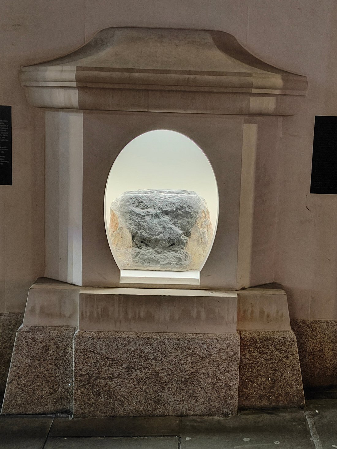
Today it sits behind a protective grille at 111 Cannon Street. The City of London describes it as an irregular piece of oolitic limestone and notes that the name was recorded by around 1100.
Its original purpose is unknown.
That uncertainty has proved irresistible.
London Stone has variously been imagined as a Roman marker, a symbolic centre of the city, an ancient sacred stone and a key point within London's occult geography.
There is an important reality check here.
The City of London explicitly says that modern claims about London Stone being an ancient object of veneration or possessing occult significance are unsubstantiated.
That does not make the Stone boring. Quite the opposite.
We have an object that has stood within London's mental landscape for at least nine centuries, whose original purpose remains unclear and around which successive generations have constructed new meanings.
That is precisely the sort of object Sacred Illusion is interested in.
The London Stone–St Paul's–Tower alignment
One frequently repeated London ley theory draws a relationship between London Stone, St Paul's Cathedral and the Tower of London.
It is visually attractive because all three places possess enormous symbolic weight.
But the historical stories attached to the alignment need separating from the geometry itself.
Claims that St Paul's replaced a prehistoric Druidic stone circle, for example, circulate widely in alternative histories of London but are not established archaeological history. Similar stories describe the Tower as having been deliberately placed upon a prehistoric sacred mound.
These traditions belong to London's alternative sacred geography rather than its securely documented archaeology.
That still makes the alignment worth plotting.
The interesting experiment is to map the points precisely, examine what actually aligns, research when each site acquired its importance and then ask whether the relationship requires anything beyond coincidence and the constraints of a very old city.
The Strand Ley
Another claimed London alignment has rather better credentials within ley-line history itself.
Modern researcher David Furlong describes a line running from St James's Palace eastwards through or near a series of significant churches and sites, including St Martin-in-the-Fields, St Mary-le-Strand, St Clement Danes and other historic points before continuing towards the East End.
Versions of this alignment are sometimes called the Strand Ley.
Furlong attributes an earlier version of the line to Watkins.
This is an excellent urban ley to investigate because the Strand is already an old route linking Westminster and the City.
That presents two competing explanations.
Perhaps the churches preserve something older.
Or perhaps significant buildings naturally accumulated along one of London's major historical corridors.
The second explanation is considerably less mysterious, but it is not trivial. Sacred architecture clustering along established movement routes tells us something important about how cities create and preserve meaning.
The Hawksmoor churches and London's occult map
London's ley-line story took another turn through literature and psychogeography.
The eighteenth-century churches associated with architect Nicholas Hawksmoor became central to a very different kind of London mapping.
Writer Iain Sinclair explored their geographical relationships in Lud Heat, imagining the churches as powerful points within an urban network. Alan Moore later drew heavily on this tradition in From Hell, turning London itself into an occult geometry of architecture, history and violence.
This is not archaeological evidence for an ancient ley network.
It is something else that Sacred Illusion should take seriously: the cultural life of a map.
Once a pattern is drawn across a city, people begin walking it, writing about it and noticing the city differently.
The map changes the experience of the place.
Whether or not the original line possesses physical reality, it can acquire cultural reality.
London's occult geography partly exists because generations of writers, artists and walkers have made it exist.
Sacred geometry or coincidence?
Geometry is seductive. A triangle between three famous sites can look astonishingly precise. Add another point and suddenly a pentagram, axis or larger system appears.
London makes this particularly easy because there are so many historically significant points available.
That does not mean every pattern is meaningless.
It means we need to know how the pattern was created.
Was the geometry defined before the sites were selected? Are equally important places excluded because they fail to fit? How wide is the alignment? Would moving one point slightly produce another equally impressive pattern?
These are the same questions we use elsewhere in Sacred Illusion, but London raises the stakes because the city provides an almost unlimited number of candidate points.
A good urban ley is therefore not simply a straight line.
It is a line with a story strong enough to survive investigation.
What London teaches us about sacred geography
The most interesting thing about London may be that we do not need to choose between "everything is random" and "the city was secretly engineered as an energy machine".
There is a huge middle territory.
London contains real sacred infrastructure.
Churches. Abbeys. Processional routes. Burial grounds. Holy wells. Ceremonial avenues. Political centres. Protected vistas. Ancient boundaries. Places people have travelled towards, prayed within and organised power around for centuries.
Those relationships matter even if they carry no measurable invisible energy.
A city can possess sacred geometry because human beings repeatedly build meaning into space.
The question is whether anything else is happening as well.
Three London alignments worth investigating
If you want to explore London's ley-line tradition yourself, I would start with three very different cases.
1. Tower of London → St Paul's → Westminster
Do not begin by assuming it is an energy line. Walk the broader historic route instead.
The British Pilgrimage Trust's London Sovereign Line provides a useful framework through the city's historic sacred and political centres. Notice the relationship between churches, boundaries, monuments and the Thames as you move west.
This is the strongest example of a route whose cultural significance is real, regardless of its energetic interpretation.
2. The Strand Ley
Map the proposed alignment through the Strand churches and compare it with London's historic street pattern.
Ask whether the sites form an unusually precise relationship or whether their distribution is exactly what we would expect along a major historical route.
Then walk it. Urban fieldwork often reveals relationships that a map cannot.
3. London Stone → St Paul's → Tower of London
This is the more speculative experiment.
Plot the points yourself rather than copying an existing diagram. Research what is actually known about London Stone and the history of the other sites.
Then compare the documented history with the later sacred-geography claims.
This is a perfect Sacred Illusion investigation because the mystery does not disappear when some of the mythology proves difficult to substantiate.
It simply changes shape.
How to test a London ley line
Urban ley hunting needs slightly different rules from rural fieldwork.
London's density means coincidence is a much bigger problem, while modern buildings, roads, underground infrastructure and centuries of redevelopment make the physical landscape much harder to interpret.
Start by selecting the sites before drawing the line. Plot their exact coordinates, measure how far each sits from the proposed centre, and research when each became significant.
Then walk the route.
Look for older street patterns, changes in elevation, watercourses, churches, boundaries and sightlines. Record what you notice rather than what you expected to find.
Some ley hunters also use dowsing or subjective sensations. Those may form part of personal practice, but they do not prove that the mapped alignment represents an external energy field.
The more crowded the city, the more useful scepticism becomes.
What about Freemasons and secret planning?
London is full of architecture associated with symbolism, geometry and organisations that themselves use symbolic systems.
That makes Freemasonic theories almost inevitable.
Freemasonry does place substantial symbolic importance on geometry and architecture. Individual architects and patrons have also belonged to Masonic traditions.
That does not demonstrate that London's landmarks were collectively positioned to create a secret energy network.
The leap from "geometry mattered to these people" to "they engineered an occult grid beneath London" requires historical evidence that has not been demonstrated.
This is another useful Sacred Illusion rule: symbolic intention is not the same thing as energetic engineering.
We can explore the first without assuming the second.
So, are there ley lines in London?
There are certainly alignments. There are certainly deliberate routes, architectural axes and long-distance sightlines. There are unquestionably sacred and ceremonial relationships between places.
Modern London's planning rules even preserve some important visual lines deliberately.
What has not been established is that these relationships form an invisible network carrying spiritual energy through the city.
But London makes the question unusually rich. Under every modern layer lies another London.
Roman roads beneath medieval streets. Lost rivers beneath office blocks. Churches rebuilt on older churches. Royal routes crossing commercial ones. Forgotten wells hidden behind ordinary walls.
Perhaps London's ley lines are physical energy channels. Perhaps they are patterns created by history. Perhaps they are stories we draw across the city because certain places continue to feel connected.
The only useful way to find out is to keep the map in one hand and the evidence in the other.
Frequently asked questions
Are there ley lines under London?
Many writers and practitioners have proposed ley-line alignments through London, but there is no scientifically verified map of energy lines beneath the city. Some claimed alignments connect genuine historic sites and routes, which can still make them interesting to investigate.
Does St Paul's Cathedral sit on a ley line?
Several alternative sacred-geography maps place St Paul's on claimed London alignments. There is no established evidence that the cathedral sits on a measurable energy line. Its position does, however, make it one of London's most important visual and symbolic landmarks.
What is the Strand Ley?
The Strand Ley is a proposed alignment connecting a series of significant sites across central London, including several historic churches. Versions of the alignment appear in modern ley-line literature and have been associated with Alfred Watkins' ideas.
Is London Stone part of a ley line?
Some ley-line theories connect London Stone with St Paul's and the Tower of London. The City of London notes that the Stone's original purpose is unknown and that modern occult interpretations are unsubstantiated.
Did Freemasons design London's ley lines?
There is no established historical evidence that Freemasons designed a hidden London energy network. Masonic traditions do place importance on geometry and architecture, but that does not prove deliberate construction of ley lines.
Can I walk London's ley lines?
Yes. Claimed alignments can be explored as urban walks. Treat the route as an investigation rather than assuming the ley-line theory is correct, and compare what you encounter with historic maps and reliable records.
Continue exploring
What Are Ley Lines? History, Evidence and the Mystery of the Old Straight Track
Start with the origins of ley-line theory and the difference between landscape alignments and later Earth-energy beliefs.
How to Find Ley Lines Near You: Maps, Methods and Fieldwork
Learn how to plot and test possible alignments for yourself.
The Earth's Energy Grid: Theories, Maps and the Search for a Hidden Network
Explore how local ley-line theories expanded into planetary-grid models.
Earth Gridwork: A Practical Guide to Working With Sacred Landscapes
Explore the modern practice of engaging with sacred sites, claimed nodes and landscape energy.
Sacred Earth
Explore sacred places, pilgrimage, landscape mysteries and future Sacred Illusion Node Quests.